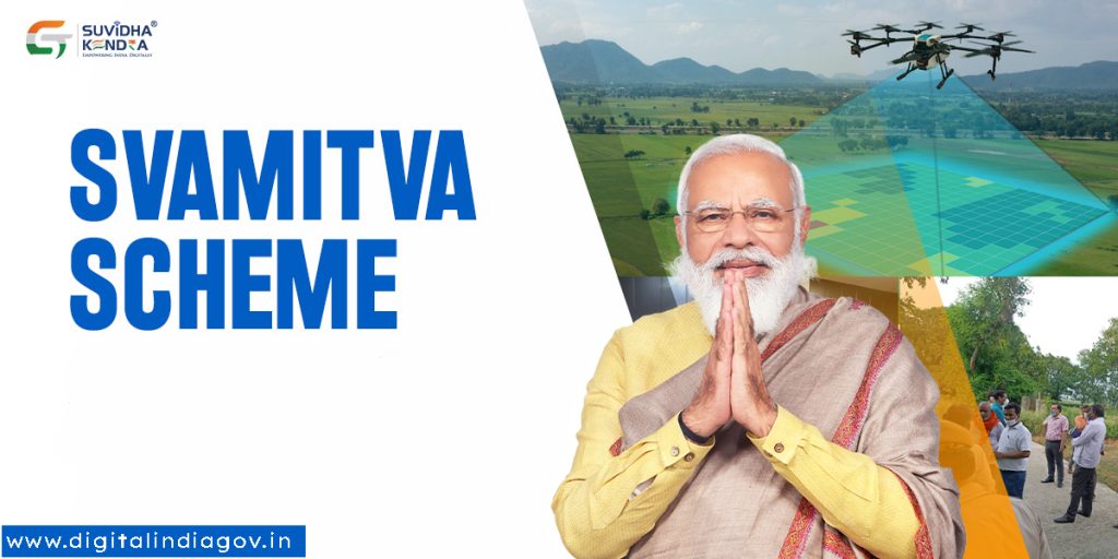
Svamitva Scheme:- An integrated property validation solution is made possible for rural India through the Central Government’s SVAMITVA scheme, which entails mapping village areas and surveying them using makeshift technology. Using the majority of modern drone technology, this is the first large-scale exercise of its kind, benefiting millions of rural property owners in every village across the country. On April 24, 2020, which is also National Panchayat Day, it was first introduced. The Ministry of Panchayati Raj (MoPR) will be the Nodal Ministry for this scheme.
Contents
About the Svamitva Scheme
- Survey of Villages and Mapping with Improvised Technology in Village Areas is the full name of SVAMITVA.
- The State Panchayati Raj Department, the Nodal Ministry, the Revenue Department, and the Land Records Department will collaborate in each state to implement the program’s goals.
- The scheme’s primary goal is to offer rural India an integrated property validation solution.
- Under this scheme, landowners will receive SVAMITVA Property cards from government authorities.
- To define rural Abadi areas, drone surveying technology and Continuously Operating Reference Stations (CORS) will be employed.
- This will assist homeowners in keeping their homes in populated areas and utilizing them as collateral for loans or other monetary needs.
- In a four-year period, starting in 2020 and ending in 2024, drone mapping will be gradually carried out throughout all of the villages.
- The program currently only covers the following six states: Madhya Pradesh, Maharashtra, Haryana, Uttar Pradesh, and Uttarakhand.
- The country’s central government is providing funding for the scheme, with Rs 79.65 crores set aside for the project’s pilot phase.

Also Read:- Senior Citizen Saving Scheme Interest Rate
Activities under the Svamitva Scheme
The Scheme’s principal undertakings are:
- Construction of the Continuous Operating Reference System (CORS) – CORS is a network of reference stations that offers a virtual base station for long-range, high-accuracy network RTK corrections with real-time, centimeter-level horizontal positioning. The CORS network supports land demarcation, precise georeferencing, and ground truthing.
- Large-scale drone mapping: The Survey of India will employ drone surveys to map inhabited rural areas, or abadis. In order to grant ownership property rights, it would produce precise and high-resolution maps.
- program to educate the rural populace about the advantages of the surveying technique.
- establishing a unit for program management at the federal and state levels.
- Creation and Upkeep of the Programme Drone survey integration and dashboard The Ministry’s spatial planning application utilizes spatial data and maps to facilitate local planning.
- Maintaining national and regional workshops and documenting best practices.
Objectives of the Svamitva Scheme
The following are the primary goals of the Svamitva Scheme:
- As a result, rural residents will have greater financial stability because they can use their land or other assets as collateral to get a loan or other financial benefits. Ignorance has led to poor record-keeping and documentation of the land division and records.
- The government wants to establish precise land records for rural planning through this program.
- It will make property taxes easier to assess. In states with devolved property taxes, general practitioners or state coffers receive the property tax revenue directly.
- GIS maps and appropriate survey infrastructure will be used by various government departments.
- Utilizing GIS maps will additionally enhance and support the Gramme Panchayat Development Plan (GPDP).
- In rural areas, there are still many unresolved legal and property-related disputes. Also, this project will assist in resolving these problems.
Benefits of the Svamitva Scheme
- The rural residents will receive official documentation for the property so they can use it for additional financial purposes.
- The government and authorities will have a better understanding of the distribution of land and properties through routine inspections and drone surveys.
- Through this project, property rights will become clearer.
- Once stronger regulations and documentation are in place, there won’t be any unlawful attempts to take possession of another person’s property in the village.
- The landowners may also use the SVAMITVA Property card as a temporary identity.
Scope of the Svamitva Scheme
- Every village in the nation that this program will eventually cover. The entire project is probably going to take place between April 2020 and March 2025, a span of five years.
- In FY 2020–21, the scheme’s pilot phase included the states of Haryana, Karnataka, Madhya Pradesh, Maharashtra, Uttar Pradesh and Uttarakhand, Punjab, Rajasthan, and Andhra Pradesh; it also included the creation of CORS networks in those states.
Working on the Svamitva Scheme
Three phases comprise the implementation of the Svamitva Scheme.
- Pre-Survey
- Survey Activities
- Post Survey Activities

Also Read:- Mukhyamantri Jan Kalyan Sambal Yojna
Features of the Svamitva Scheme
- A project called Svamitva Yojana makes use of contemporary technology to create land ownership records in rural areas.
- This plan was presented since many rural villagers do not have the documentation required to establish their ownership of their lands. To further verify or attest to the properties, no survey of the populated areas of the villages is conducted.
- The ultimate goal of this project is to grant ownership rights to villagers as a legitimate means of resolving property-related issues in rural India.
- Every property measured and delineated in the community will have a property card made and delivered to the owner. The Land Revenue Records Department will accept the property cards.
- Property cards are carried by villagers and are official documents that can be pledged as security for bank loans.
- These GIS maps are available for use by all government departments. This scheme generates a better quality Gramme Panchayat Development Plan (GPDP) using GIS maps.
- Furthermore, the smartphone app eGram Swaraj is now available. The app provides a centralized location where the nation’s Panchayats can review data related to their planning, accounting, and monitoring requirements.
- This app and the eGramSwaraj portal provide reports and the status of the activities that the government has undertaken and finished under this scheme.
Significance of the Svamitva Scheme
In India, the Svamitva Scheme is very important for a number of reasons:
- Evidence of land ownership that cannot be tampered with will be made available by digitizing the land records. It advances India’s digitalization concept.
- The SVAMITVA Scheme will leverage digital mapping to propel the country’s drone industry forward.
- The manufacturing sector and drone operators stand to gain greatly from the growing use of drone technology.
- The SVAMITVA Scheme will support MSMEs and startups in India.
Challenges in Implementing the Svamitva Scheme
Several formidable challenges face the implementation of the innovative Svamitva Scheme. These challenges include:
- Uncertain Legal Applicability of SVAMITVA Cards
- No particular clause is included to ensure the property cards’ legal validity.
- differences between state laws governing the practice of keeping land records.
- appropriate inclusion of underrepresented groups, such as women, sharecroppers, scheduled castes, and scheduled tribes.
- In states in the Southeast, the Gramme Panchayat needs to have the legal authority to collect property taxes.
- Appropriate Grievance Redressal System.
- appropriately adhering to the Open Geospatial Consortium guidelines.
Need for Svamitva Scheme
The Indian government has launched numerous initiatives in the past to promote development in the country’s rural areas. SVAMITVA, the Survey of Villages and Mapping with Improvised Technology in Village Areas, is also expected to adopt this approach.
- The scheme will benefit more than 6 lakh rural people if the pilot project is successful.
- Additionally, the SVAMITVA Yojana makes it easier to monetize rural residential assets for a range of credit and financial services.
- The “Record of Rights” would become accessible upon completion of property registrations through the SVAMITVA Plan.
Also Read:- PMSBY Scheme
Svamitva Scheme Login Process
In order to log in, simply follow the steps listed below:-
- To begin with, you must click on this link to go to the Svamitva Scheme website.
- Your screen will open to the home page.
- You need to click the visible login button in the menu bar.
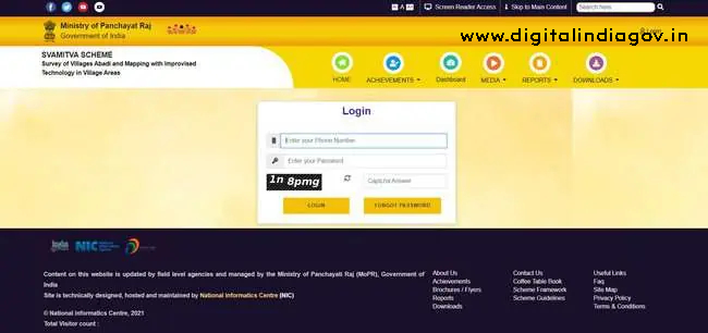
- Your screen will open to a new page.
- You need to enter your phone number.
- You need to enter your password and the verification code.
- In order to properly log in, click log in.
FAQ’s
Q. How do I register for the SVAMITVA scheme?
Ans- Svamitva Scheme Online Registration
- Select the ‘New User Registration’ option located on the homepage.
- Fill out the application form on the registration form page with your basic information, such as your name, address, phone number, email address, and details about your land.
Q. What is the Swamitva scheme of government?
Ans- Through the use of drone technology to map land parcels, SVAMITVA, a Central Sector scheme of the Ministry of Panchayati Raj, will be able to provide a ‘Record of Rights’ to village household owners in the form of legal ownership cards (also known as property cards or title deeds).
Q. When did the Swamitva scheme start?
Ans- On April 24, 2020, the SVAMITVA Scheme’s pilot phase was introduced, with plans to go live in 2020–21. The scheme’s nationwide rollout began on April 24, 2021.
Q. WHO launched the Svamitva Scheme?
Ans- On April 24, 2021, National Panchayati Raj Day, the Hon’ble Prime Minister launched SVAMITVA, a Central Sector Scheme of the Ministry of Panchayati Raj, across the country. This came after the program’s successful pilot phase (2020–2021) in nine states.
Suggested Link:- Mobile Number Tracker Online
@PAY